
SNP Maps Now Offered in Digital Format
By Jeff Monroe, Jess LaPolla, and Nancy Doyle
The newest editions of PATC’s renowned trio of Shenandoah National Park (SNP) maps are now available for use on your smartphone! The digital version of these maps will be available for purchase and download exclusively through Avenza for use on your phone while hiking. Avenza is a free app for your mobile device for downloading maps from the PATC Avenza map store. Paper maps will still be available for purchase, but the newest editions of maps 9 and 11 are currently available exclusively through Avenza.
Fully updated using input from PATC volunteers including the GIS Committee, PATC GPS Rangers, PATC Trail Patrol, and trail maintainers, these full color maps encompass many of your favorite places to hike, camp, and backpack in and around SNP. The latest editions of the North, Central, and South Park districts (Maps 9, 10, and 11) offer the most accurate trail locations and information available including updated trail access points, side trail closures and reroutes, stream and river variations, current parking areas, and many others. PATC maps are universally regarded as the best trail maps for Shenandoah National Park, and are the maps used by the SNP Rangers!
Each revised map features PATC’s newly designed cover by Alan Kahan with a color photograph from the North, Central, and South districts of SNP. All three maps include AT shelters and PATC cabins for planning overnight trips.
The SNP North District, PATC Map 9 Edition 20 (2025), covers 28 miles of the Appalachian Trail and all side trails totaling 144 miles of hiking trails. Included in Map 9 are popular hikes including Dickey Ridge, Fox Hollow, Sugarloaf, Compton Peak, and many others.
The SNP Central District, PATC Map 10 Edition 23 (2023), covers 36 miles of the Appalachian Trail and all side trails totaling 219 miles of hiking trails. Featuring a photograph of the Old Rag rocky pinnacle on the cover, Map 10 covers the most hiked part of the park. It includes significant GPS updates to Skyland-Big Meadows horse trails, as well as Old Rag Mountain, White Oak Canyon, Hawksbill, and other popular trails and destinations.
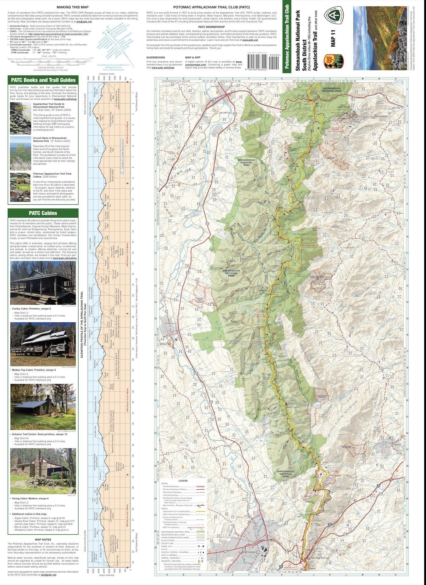
The SNP South District, PATC Map 11 Edition 18 (2025), covers the longest section of the AT within the park, 45 miles of the AT, and all side trails totaling 148 miles of hiking trails. It also includes an elevation profile of the AT from Swift Run Gap to Rockfish Gap. Hiking trails include Blackrock, Hightop Mountain, Rockfish Gap, Doyles River, and others.
In addition to the superior data collected by the Rangers, the all-volunteer, map-making GIS Committee imported authoritative data from GIS software company Environmental Systems Research Institute (ESRI) including a base map of LIDAR data sets used for measuring elevation to create contour lines. The committee imported data from VDOT to determine boundaries, structures, and features to include on the map. Other data layers include state of Virginia administrative boundaries for counties and towns, the Virginia road centerline map data, Rapidan Wildlife Management boundaries, river and trailhead locations, mile markers, and infrastructures.
Why is a PATC map the best trail map available to hikers? The methods used to collect our data come from boots on the ground. Unlike competitors’ map makers who rely solely upon satellite and second party data, PATC itself is the primary source of trail data. Volunteers measure every trail in the park according to strict internal standards and continually feed updates to the GIS Committee.
Using advanced equipment, the GPS Rangers collect point and line data to create the trail line by hiking each trail. This pinpoint data affords detailed accuracy that a satellite cannot provide. Waypoints, such as springs, shelters, benches, cabins, signage, overlooks, and walls are fully notated and photographed. Much of this precise data is included in a PATC map The Shenandoah National Park Rangers use and depend upon PATC maps to do their work for the national park. Is it any surprise that PATC maps are the industry standard that no other maps can equal? Purchase and download PATC maps here.